Nagaon District of Assam
The Central Assam District of Nagaon (spelled by the British as Nowgong) is one of the largest districts of Assam. It sprawls across almost four thousand square kilometres of fertile alluvial plains and thickly forested hills. Lakes and marshes dot the landscape of Nagaon.
The mighty river Brahmaputra flows along the northern periphery of the Nagaon district. Other major tributaries meandering through the district such as Kolong , Kopili and Jamuna drain into the Brahmaputra.

Nagaon District
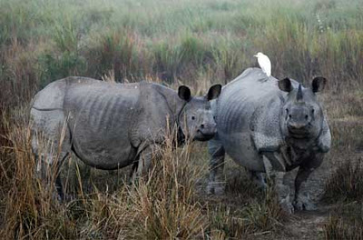
Lying at a distance of 123 kilometres by road from Guwahati, Nagaon town constitutes a vital corridor linking the Upper Assam districts of Golaghat, Jorhat, Sivasagar, Dibrugarh, Tinsukia and the North Assam districts of Sonitpur and N.Lakhimpur. The famous Kaziranga Game Sanctuary, home of the one-horned rhinoceros, stretches from the north-eastern parts of the district and spills into bordering Golaghat.
The history of the district as an administrative unit can be firmly traced only from the time of the British annexation, Nagaon passed into British hands in 1826 and was declared a district in 1833. The headquarters of the district were established in Nagaon in 1839. At one time, a large chunk of the Naga Hills, the Mikir Hills and North Cachar Hills were part of the district. With the passage of time, they were sliced away to form separate tribal district with autonomous hill councils.
During Freedom struggle, freedom fighters of Nagaon district actively participated in the struggle. The year 1942 saw the martyrdom of four freedom fighters at Barhampur, when police opend indisriminate firing on a group of people who had assembled to have a community feast after peacfully snatching back a Shanti Sena camp nearby. Those who sacrificed their lives there included the 57 year old Bhogeswari Phukanani, apart from Lakshmikanta Hazarika, Thagiram Sut and Boloram Sut. At Bebejia, also in Nagaon district, were killed Kalai Koch and Hemkanta Barua, while two others Hemaram Keot and Gunabhiram Bordoloi laid down their lives at Jongalbalahu, followed by the martyrdom of Tilak Deka at Barapujiya.
Weather is wet and humid. The absence of a dry, hot summer and plentiful rainfall are the main characteristics. Winter stretches from December to February. It is followed by the pre-monsoon season of thunderstorms. The South-West Monsoon lasts from June to October. January the coldest month with temperatures varying from 10 degree celsius to 24 degree celsius. April and May are the warmest months with the mercury soaring to 35 degree celsius at times.
Nagaon is well connected by road, rail and river. The North -East Frontier railway has its Divisional headquarters in Lumding which is connected with all important centres in the district. The conversion of the meter gauge track to broad gauge from Guwahati to Lumding has eased the transportation problem of the region.
While the Brahmaputra offers tremendous scope as a waterway, rivers like the Jamuna , Kolong and Kopili are frequently used for water transport. Dhing town on the Brahmaputra was a well known steamer ghat in days past. Even now, milk and agricultural products are transported from Dhing by boat.
The road, rail and river network serve as the outlet for the fertile hinterland. Among the major agricultural products are rice, sugarcane, mustard, jute, coconuts, bananas and vegetables.
Many rice and oil mills have come up over the years. The jute and sugar sector have made a mark. Many small scale industrial units have developed. Proper geographical exploration of the alluvial tracts may yield valuable oil-bearing tertiary formations.
Among the developmental programmes already implemented are the Integrated Rural Development Programme (IRDP), the Jawahar Rozgar Yojana (JRY), the training of Rural Youth for self employment (TRYSEM), Development of Women and Children in Rural Areas (DWCRA), and being implemented are Integrated Child Development Scheme (ICDS), Adult Education, National Watershed Development Programme for Rainfed Areas (NWDPRA), Oilseed Production Programme, the special Jute Development Programme and the Integrated Programme for Rice Development.
One welfare organisation of Nagaon that deserves special mention is the Sreemanta Sankara Mission set up in 1950. The Mission consists of an Eye Hospital, an Orphanage and a School for the blind and its activities are spread all over Assam.
Among places of interest are Batadrava, birthplace of Srimanta Sankardeva, the outstanding vaishnava reformer of the sixteenth century. Dabaka, located 35 Kms away from Nagaon, is mentioned in the Allahabad inscription of Samudra Gupta and littered with ruins of ancient temples. Hojai renowned as Assams’s granary, is famous for agar, an aromatic substance which is used in perfumes and is widely exported to Arab countries.
The SOS village in Hojai, opened in the aftermath of the Nellie massacre in 1983, is a unique institution for orphaned children. Jugijan in southern Nagaon, boasts of the remnants of a fort, and temples decorated with bas-reliefs. Kaliabor, by the Kolong river, has been the scene of several critical battles of the Ahoms. The great peasant’s uprising of 1861 took place at Phulaguri, where Lt. Singer, the Assistant Commissioner, lost his life in attempting to subdue the sentiments of an aggrieved peasantry.
Map of Nagaon, Assam:
[googlemap width="614" height="400" src="http://maps.google.co.in/maps?q=nagaon+assam&oe=utf-8&client=firefox-a&ie=UTF8&hq=&hnear=Nagaon,+Assam&gl=in&t=m&vpsrc=6&ll=26.351575,92.690277&spn=0.061529,0.105228&z=13"]

